
If you click on the picture of the plaque above and read it, you will see that the women of the Hillside Club had all the best intentions when they succeeded in implementing a design for development of Daley’s Scenic Park Tract that took into account the rolling, twisting nature of the topography of the Berkeley Hills. Little did they know, and nor did the City of Berkeley and the architects Maybeck, Coxhead, and Bolton, that the area would become one of the most dangerous places in North America in which to live.
The very topography, and the beauty of the landscape, all the way along the lower part of the Berkeley Hills, was formed by thousands of years of ripping and wrenching of the land by the inexorable movement of the chunk of land known as the Pacific Plate, sliding in a north-west direction past the North American plate. Every 100 to 200 years or so, a massive earthquake of magnitude of about 7 or 8 on the Richter Scale would rip open the hillside with a ten to twenty foot horizontal jump, all in the space of a minute or two, sending shock waves hundreds of miles across the State of California.
Of course, it didn’t matter when nobody lived there. Even when the only inhabitants were Native Americans, they were so spread out, and their homes so flimsy, that the chances of getting hurt in an earthquake were slim. The last big earthquake on the Hayward Fault, with a magnitude of about 7 on the Richter Scale, occurred on October 21, 1868, and was but a distant memory when the Hillside Club ladies planned their paradise of winding streets, retaining walls, and stairways. That earthquake left no trace in Berkeley, because only the southern portion of the fault ripped open from San Leandro south through Hayward and Fremont towards San Jose.
Even the Great San Francisco Earthquake of 1906, which happened when they were in the middle of their design, apparently did not affect their planning, probably because all the evidence in that event pointed towards a different fault ripping open near Olema in Marin County. They probably thought they were building in an area of stability, far away from the constant dangers of the San Andreas fault.
The fact is, they just didn’t know. There was no way they could know. The tools they needed to determine that they were building right on top of a fault even more dangerous than the San Andreas, just hadn’t been invented yet, and it would be another fifty years before science advanced enough for us to realize that the area is nothing more than a ticking time bomb. It was the same up and down the Hayward Fault. The area was urbanized, and houses, schools, roads, offices, pipelines, and a great university, were built right on top of the fault before anybody knew how vulnerable it is.
Two facts have conspired to make Daley’s Scenic Park Tract a very, very dangerous place in which to live. Both are related to the passage of time.
Firstly, the northern section of the Hayward Fault from Berkeley north to San Pablo Bay has not broken for at least 240 years, and all of the scientific evidence points towards the fact that a massive rupture in this area is long overdue.
Secondly, since the 1923 Berkeley Hills Fire destroyed many of the homes in the area, the vegetation surrounding the wood shingle homes has grown so thick,

and so far out of control in the intervening 85 years, that a massive firestorm of the magnitude of the 1991 Oakland Hills Fire is almost inevitable. And a combination event is highly likely. When the earthquake occurs, a firestorm will certainly result.
When the ladies of the Hillside Club started their planning for the area in 1903, the state of the science of geology was quite primitive. Even though a good foundation had been laid by Charles Lyell in the early 1800’s, which described how most geologic processes were very gradual and occured at much the same rate through time, nothing in the science yet addressed the very sudden alteration of the landscape by means of earthquakes and volcanoes. Geological exploration was done with hand tools, measuring instruments were primitive, and the start-of-the-art technology used for getting around was the horse.
Consider the following:
- The science of seismology began to be developed in the 1880’s, and began to provide useful information in the wake of the 1906 San Francisco earthquake, too late to be of much help before the plans for development on the Hayward Fault through Berkeley were well underway.
- The seismograph, or seismometer, was not invented until 1880, and began to be used extensively to monitor earthquakes in the early 1900’s.
- Continental drift was first postulated by Alfred Wegener in 1912, but nobody believed him. It was not until the 1960’s that Tuzo Wilson developed the first serious scientific proof of what came to be known as plate tectonics , which was able to be applied to explain earthquakes like those which occur on the San Andreas and Hayward faults.
- Although Geochronology, the science of dating rocks and archaeological evidence began to be developed by Arthur Holmes around 1911, radiocarbon dating was not developed until the late 1940’s, and radiometric dating was not developed until the 1950’s.
- The Richter Scale, a standard for measuring the magnitude of earthquakes, was not invented until 1935.
- Aerial photography and photogrammetry, which allows the accurate mapping of both planimetric and contour features from photographs taken with an aerial camera, was not invented until World War II, and began to be used commercially during the 1950’s.
- Satellite imagery, while used by the military beginning around the 1960’s, was not opened up and made available to the public at large until the 1980’s.
- The science of paleoseismology, the study of historical earthquake evidence, did not emerge as a discipline until the 1990’s.
It’s no wonder that, with the absence of physical evidence of the Hayward Fault on the ground, the lack of knowledge about what really causes earthquakes, and the absence of tools and scientific methods to accurately locate faults, the entire Hayward Fault was built upon, mostly during the first half of the last century, long before it became common knowledge that the makings of a disaster was in the works.
For example, here is the former Hillside Elementary School at 1581 Le Roy Avenue,
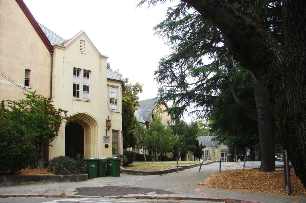
designed in 1925 by Walter H. Ratcliff, Jr. Would anybody in their right mind build a school for children right on top of an earthquake fault? The fact is, nobody knew.
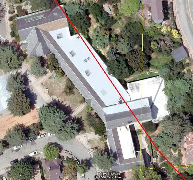
Take a look at this satellite view of the Hillside Elementary School from the Google Earth Hayward Fault Helicopter Tour. The red line is the Hayward Fault, running right underneath the classrooms at the rear of the school. No wonder the School Board closed and abandoned it in 1983!
It has taken more than fifty years of scientific development and study, using the disciplines of plate tectonics, remote sensing, paleoseismology, geochronology, and a host of other disciplines related to seismology to determine this, culminating in the publication of these images by the USGS over the past couple of years.
The ladies of the Hillside Club, the architects, and all involved, would have been shocked, absolutely shocked, if they had been able to find out what we know about the Hayward Fault today.

How cool is this! I was just t’inking of this kind of post, and there you were on my stat counter. Get outta heah! So I hung you onto today’s Ladda.
We are all pretty caught up in Water and failing levees and the Corps of Engineers right now and y’all are all caught up in Fire and quaking Earth and even da’Scouts have to deal wit’da Wind.
The 4 Elements
The 4 Directions
The 4 Noble Truths
Jeez Louie, it is just getting hard for us stupid clueless idiots to find somewhere to live, eh?
Thank you for checking in,
Editilla~New Orleans News Ladder
By: New Orleans News Ladder on June 25, 2008
at 4:44 pm
Hey, I read a lot of blogs on a daily basis and for the most part, people lack substance but, I just wanted to make a quick comment to say GREAT blog!…..I”ll be checking in on a regularly now….Keep up the good work! 🙂
I’m Out! 🙂
By: online stock trading advice on January 11, 2010
at 6:19 am
Thanks for your encouragement. I have been watching the news of the devastating earthquake in Haiti, and realize that the fault situation here in North Berkeley on the Hayward Fault is the EXACT SAME type of case. You have motivated me to write the next chapter in this journal.
Andy
By: walkingthefault on January 13, 2010
at 8:15 pm
I think that is one of the such a lot significant information for me. And i am happy studying your article. However want to commentary on few normal issues, The website style is perfect, the articles is really great : D. Excellent activity, cheers
By: what is black currant oil good for on April 15, 2012
at 11:52 am